Submitted by Michael Frankfort @mfrank_76
I clearly remember sitting in a geography lesson in a dusty, cold classroom in the English midlands listening to Mr Lewin drone on and on. It must have been the late 1970’s. The only interesting thing about Mr Lewin was that he was the 1st XV rugby coach. I always wondered how a man with so little personality had achieved such an exalted position…..in my mind on a par with being the Prime Minister. However, as long as I can remember, I had always had a fascination with maps, or perhaps on this site we should call them charts…. and one day Mr Lewin began explaining how cartographers addressed the challenge of portraying what is essentially a three dimensional object, (the world) on a two dimensional plane (a piece of paper). My eyes lit up. Not only did the problem have multiple imperfect solutions but the names of the people working on this conundrum sounded like adventure itself!
Mercator, Sinu-Mollweide, Goode’s Homolosine, Peirce Quincincial and my favourite the Winkel Tripel!

So when, this week, I came across, a projection that I had never heard about in the 40 years since sitting in that classroom, I was intrigued

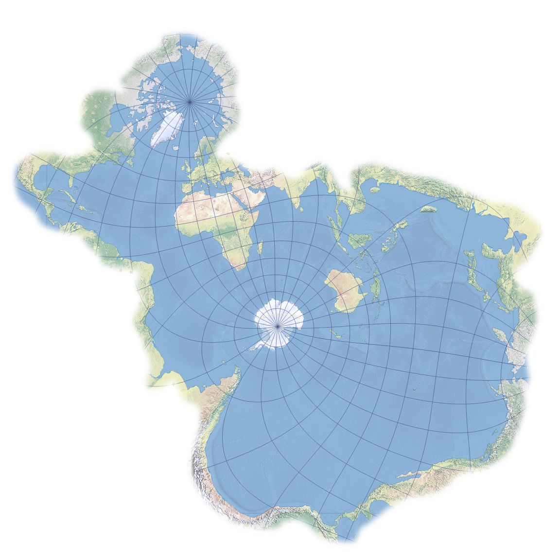
The Spilhaus Projection may be more than 75 years old, but it has never been more relevant than today. Uniquely, it centres on Antarctica. Disturbingly, it rips Asia and the Americas to shreds. And compellingly, it presents the seas and oceans – 71% of the Earth’s surface – as a unified body of water. The map was designed by a renaissance man who also invented the skyways of Minneapolis and the secret weather balloon that caused the Roswell Incident.
Dr Spilhaus was not just a distinguished meteorologist and oceanographer, but also a prolific inventor. The earth-sea is perforated by Antarctica and Australia, and fringed by the other land masses. Two small triangles, one at the top of the map and the other on the lower right hand side, mark the same spot: the Bering Strait – as a reminder that what we’re looking at is not in fact a vast inland sea, but a body of water that circles the entire globe.
On most maps, the oceans are so vast that they become easy to ignore. Rather than just use them as background noise, this map focuses on the watery bits of our planet. That’s not just a refreshingly different viewpoint but, it could be argued, also a desperately needed one.